
BEDFORD, NS / ACCESSWIRE / September 9, 2021 / (TSXV:SSE) - Silver Spruce Resources, Inc. ("Silver Spruce" or the "Company") is pleased to announce the receipt of its report from Strategic Consultants IGIS, ("SCIGIS") based in Chihuahua, Mexico, providing a comprehensive interpretation of regional ASTER (Advanced Spaceborne Thermal Emission and Reflectance Radiometer) and LANDSAT 8 OLI (Operational Land Imager) data over three exploration properties comprising El Mezquite, Jackie and Diamante (see Figure 1).
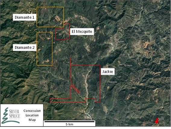
Figure 1. El Mezquite, Diamante 1 and 2, and Jackie Concession Location Map. Nicho mine development by Minera Alamos located 6 km SE of Jackie (Image taken from Google Earth).
"We continue to build on the Sonoran project geotechnical database using advanced processing techniques for re-interpretation of available ASTER and LANDSAT 8 OLI imagery. The TLALI algorithm processing clearly illustrated its capabilities in mineral and anomaly identification with clarity of spatial response," said Greg Davison, Silver Spruce VP Exploration and Director. "We are compiling and interpreting the Shortwave Infrared ("SWIR") and Visible to Near-Infrared ("VNIR") hyperspectral data from El Mezquite and Jackie rock samples in concert with the ASTER/LANDSAT alteration fields for the next phase of drill target definition after recently completing our maiden drill program on EL Mezquite and Phase 2 geological and alteration mapping on Jackie. The SCIGIS maps also will be used for focusing and planning of the targeted geological mapping program at Diamante 1 and 2 in Q4 2021."
The SCIGIS study comprised a spectral reconnaissance of the Properties (Diamante 1, Diamante 2, El Mezquite, and Jackie) to understand the structural and lithological controls in a regional context and provide additional detail on the mineral-by-mineral distribution over each of the Properties. SCIGIS research covered an area of 6,500 hectares - the map area shown in Figure 2. The ASTER imagery was processed using the proprietary TLALI algorithm, which has shown significant success in optimizing and recognizing anomalies in a wide range of geological environments from several international projects.
A second run was carried out using LANDSAT 8 OLI imagery and focus on clay minerals, ferrous iron, and iron oxide species. The reporting included a complete set of shapefiles, index raster and RGB images, index reclassifications, and various digital elevation rasters with shading and lineament extraction in ArcGIS format.
Project Geology - Spectral Response
The El Mezquite and Diamante properties each exhibit features that manifest with excellent hyperspectral signatures and responses for a broad suite of oxide and silicate minerals. The remote spectral response distribution, particularly for Jackie, is limited by extensive vegetation. A historical study of ASTER imagery was performed in 2017 principally on the Diamante and El Mezquite properties and identified hyperspectral responses interpreted as supergene oxidation and argillization with propylitic areas, the latter mainly in less altered andesites.
Figures 2 and 3 illustrate examples of the Servicio Geológico Mexicano ("SGM") alteration and the recent LANDSAT 8 OLI interpretation for the three properties mainly for the Diamante and El Mezquite projects. Data available from the GEOINFOMEX SGM web portal displayed alteration with broadly circled areas of grouped minerals or styles. It is noteworthy that the Jackie property showed only minimal LANDSAT 8 OLI responses though the evidence from the current ground exploration successfully identified significant clay and oxide minerals proximal to the Au-Ag anomaly (see Press Releases - June 10th and June 26th, 2021).
El Mezquite - A white mica-dominant assemblage with lesser jarosite, kaolinite and iron oxides, distal zones containing chlorite, and intermittent areas of aluminous minerals locally linked to potential structural lineaments, were identified by the rock hyperspectral response. The LANDSAT 8 OLI TLALI maps illustrate northeast and northwest-trending clusters tied to surfaces exposure and topographic features including faults interpreted from the magnetic and 3D IP surveys. ASTER data documented, in Figures 3 and 4, the kaolinite, alunite and pyrophyllite group, with silica spatially associated with NW-trending lineaments and, in part, were targeted by the Phase 1 drilling. Additional targets to the south of the current drilling are interpreted from the TLALI alteration maps and the initial lineament analysis.
Jackie - The Phase 1 prospecting and Phase 2 mapping programs (see Press Releases - June 10th and June 26th 2021) identified a distinctive andesite ridge with intense oxidation, silicification, argillic alteration, and a notable vegetation-free zone. This location was confirmed by the ASTER and LANDSAT 8 interpretation though was limited to a focused area with ferric oxides, kaolinite, silica and chlorite-epidote-carbonate. The oxide and silicate alteration, was verified by aiSIRIS results of rock hyperspectral analysis, represented oxidized argillic zones with low grade or bleached metal values. Rock samples collected from the northern area of the ridge also displayed intense replacement by zeolite, kaolinite, alunite, montmorillonite, opaline silica, and muscovite and contained the bulk of the anomalous gold and silver values. None of this neighboring and significant alteration was recognized by ASTER and LANDSAT 8 OLI given the coverage by vegetation during the period of image collection. Compilation of the rock sample hyperspectral data is pending and requisite for advancing the alteration mapping of the Jackie property.
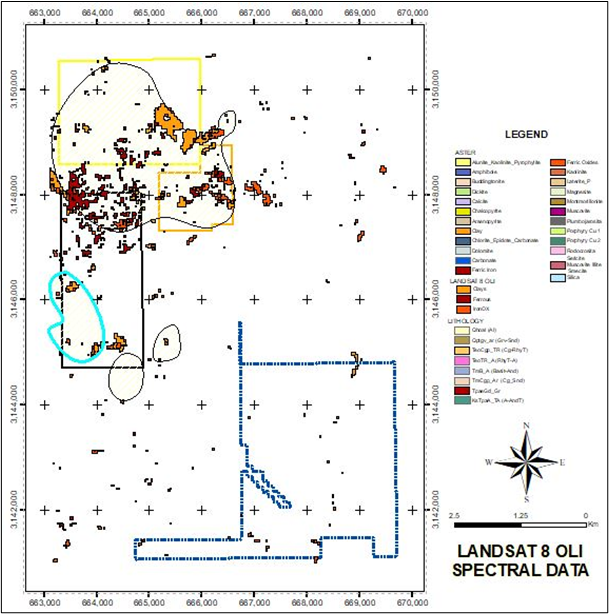
Figure 2. Distribution of clay and ferric oxide alteration from LANDSAT 8 OLI data focused around vein and disseminated mineralization targets, with outlined areas sourced from historical SGM database, on the Diamante and El Mezquite properties. Limited response on the Jackie property.
Diamante - Historical ground exploration on the Diamante 1 and 2 concessions identified mineralization accompanied by silicification, and phyllic, argillic, advanced argillic (quartz-alunite-pyrite) and propylitic (chlorite) zones, with overprinting by iron oxide and oxyhydroxide (hematite, goethite, and limonite) staining, jarosite and vuggy silica. The TLALI maps, shown in Figures 2 and 3 for the LANDSAT 8 OLI and combined LANDSAT/ASTER data, respectively, illustrate the spectral response for silicification and argillic alteration, including generic clay, alunite, pyrophyllite, kaolinite and silica, which are in part coincident with known artisanal vein workings and disseminated gold targets, such as the Southern Anomaly in Diamante 2. The areas of alteration require verification by surface exploration as part of the Phase 1 drill target definition program planned for Q4 2021.
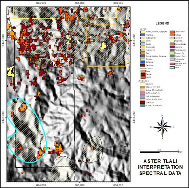
Figure 3. Distribution of alunite, pyrophyllite, kaolinite and silica from ASTER and overprinting ferric oxide alteration from LANDSAT 8 OLI data focused on Diamante 2 and El Mezquite identifying potential targets of advanced argillization and silicification, with outlined areas sourced from historical SGM database, on shaded topography.
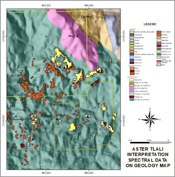
Figure 4. Distribution of alunite, pyrophyllite, kaolinite and silica from ASTER focused on Diamante 1 and El Mezquite identifying potential targets of advanced argillization and silicification, on shaded topography and regional geology, primarily the Tarahumara Formation (teal color), principal host to known mineralization.
Project Background
The 180-hectare ("ha") El Mezquite and 1,057-ha Diamante Concessions are drill-ready precious metal (Au-Ag) projects, located 10 and 5 kilometres respectively, from Tepoca and 165 km southeast of Hermosillo, Mexico. Diamante 1 is situated adjacent to the west of the El Mezquite project. Diamante 2 is located 700 metres south of Diamante 1. The grassroots 1,130-ha Jackie property is located less than two kilometres south of our El Mezquite and Diamante properties and directly adjacent to the west boundary of Minera Alamos' Santana project.
The Properties are well situated in logistics for exploration, adjacent to each other, and six to fifteen kilometres west and northwest of the Minera Alamos' Nicho deposit in mine development.
The Properties are easily accessible from Mexican Highway #16, which transects Diamante 1 and El Mezquite, ranch trails and dry riverbeds to Diamante 2, and dry riverbed access from the pueblo of La Quema, west of Highway #117 to Jackie. High voltage power lines positioned along with Highway #16.
The El Mezquite, Jackie, and Diamante projects are currently subject to option agreements with Colibri, wherein SSE can earn 50% of the gold and silver projects by meeting specific criteria over periods of two to four years. El Mezquite and Jackie concessions currently have hyperspectral assays pending detailed interpretation from 2021 mapping and prospecting programs, and the Company recently completed Phase 1 drilling at El Mezquite.
The Properties are located within the west-central portion of the Sierra Madre Occidental Volcanic Complex within the prominent northwest-trending "Sonora Gold Belt" of northern Mexico and parallel to the well-known, precious metals-rich Mojave-Sonora Megashear.
Several nearby large operating mines include Alamos Gold's Los Mulatos gold mine and Agnico Eagle's La India gold mine located 50 and 58 kilometres to the northeast, respectively, Agnico's Pinos Altos Mine, 100 kilometres southeast and Argonaut's La Colorada Mine, 100 kilometres west. Exploration in the surrounding area is very active, with adjacent and nearby properties held by Evrim, Newmont, Garibaldi, Kootenay Silver, and Penoles.
Qualified Person
Greg Davison, PGeo, Silver Spruce VP Exploration and Director, is the Company's internal Qualified Person for the El Mezquite, Jackie and Diamante Projects and is responsible for approval of the technical content of this press release within the meaning of National Instrument 43-101 Standards of Disclosure for Mineral Projects ("N.I. 43-101"), under TSX guidelines.
About Strategic Consultants IGIS
Based in Chihuahua, Mexico, Strategic Consultants have been in mineral exploration for over 30 years, having GIS and Remote Sensing as powerful tools to search for mineral deposits. Strategic Consultants developed an innovative cloud-based algorithm capable of processing an ASTER image anywhere in the world, in a matter of minutes, yielding up to twenty-five spectral signatures representing the same amount of minerals, each in a separate ArcGIS shapefile. This procedure allows to establish types of alteration, a rock-mineral relationship or geological-mineral characteristic, and helps to select specific areas of interest and objectives. Major mining companies, such as Agnico-Eagle México and Redline Minerals Inc., have used the algorithm for exploration in brownfields and greenfields properties in México and the United States.
About Silver Spruce Resources Inc.
Silver Spruce Resources Inc. is a Canadian junior exploration company which has signed Definitive Agreements to acquire 100% of the Melchett Lake Zn-Au-Ag project in northern Ontario, and with Colibri Resource Corp. in Sonora, Mexico, to acquire 50% interest in Yaque Minerales S.A de C.V. holding the El Mezquite Au project, a drill-ready precious metal project, and up to 50% interest in each of Colibri's early stage Jackie Au and Diamante Au-Ag projects, with the three properties located from 5 kilometres to 15 kilometres northwest from Minera Alamos's Nicho deposit, respectively. The Company is acquiring 100% interest in the drill-ready and fully permitted Pino de Plata Ag project, located 15 kilometres west of Coeur Mining's Palmarejo Mine, in western Chihuahua, Mexico. Silver Spruce recently signed an LOI to acquire 100% interest in three exploration properties in the Exploits Subzone Gold Belt, located 15-40 kilometres from recent discoveries by Sokoman Minerals Corp. and New Found Gold Corp., central Newfoundland. Silver Spruce Resources Inc. continues to investigate opportunities that Management has identified or that have been presented to the Company for consideration.
Contact:
Silver Spruce Resources Inc.
Greg Davison, PGeo, Vice-President Exploration and Director
(250) 521-0444
gdavison@silverspruceresources.com
Michael Kinley, CEO
(902) 826-1579
mkinley@silverspruceresources.com
info@silverspruceresources.com
ww.silverspruceresources.com
Neither TSX Venture Exchange nor its Regulation Services Provider (as that term is defined in the policies of the TSX Venture Exchange) accepts responsibility for the adequacy or accuracy of this release.
Notice Regarding Forward-Looking Statements
This news release contains "forward-looking statements," Statements in this press release which are not purely historical are forward-looking statements and include any statements regarding beliefs, plans, expectations or intentions regarding the future, including but not limited to, statements regarding the private placement.
Actual results could differ from those projected in any forward-looking statements due to numerous factors. Such factors include, among others, the inherent uncertainties associated with mineral exploration and difficulties associated with obtaining financing on acceptable terms. We are not in control of metals prices and these could vary to make development uneconomic. These forward-looking statements are made as of the date of this news release, and we assume no obligation to update the forward-looking statements, or to update the reasons why actual results could differ from those projected in the forward-looking statements. Although we believe that the beliefs, plans, expectations and intentions contained in this press release are reasonable, there can be no assurance that such beliefs, plans, expectations or intentions will prove to be accurate.
SOURCE: Silver Spruce Resources Inc.
View source version on accesswire.com:
https://www.accesswire.com/663321/Silver-Spruce-Completes-ASTER-and-LANDSAT-8-Hyperspectral-and-Image-Analysis-on-El-Mezquite-Jackie-and-Diamante-Au-Ag-Concessions-Sonora-Mexico
