
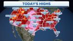
The heat has moved back into the Northeast today, with record-setting temperatures and high humidity making it dangerous to be outside for a long period of time.
LIGHTNING STRIKE OUTSIDE WHITE HOUSE SENDS 4 TO HOSPITAL IN CRITICAL CONDITION
Heavy rain is back in the forecast for the Kentucky area and across portions of the Ohio and Tennessee valleys, where flood watches and warnings remain active.
Monsoonal showers and thunderstorms continue across the Southwest, and some of that moisture will move eastward along a cold front.
Cooler air will bring needed relief to the Northwest, northern Plains and Rockies, which will help bring down the fire threat this weekend.
